Written by: Nur Batrisyia Binti Isna Elias & Hurin Hasana Binti Hasna
Edited by: Jinghann Hong & Shameeta Masilamany
Sea level rise (SLR) is among the most visible and inevitable impacts of climate change. As global temperatures climb, oceans absorb much of this excess heat and expand in a process known as thermal expansion. This means water physically takes up more space as it warms, directly contributing to rising sea levels. In parallel, vast amounts of water are being added to the ocean through the melting glacier and polar ice sheets, accelerating the rise.
Global sea levels have already risen by roughly 3.4 mm per year since 1993 (EarthData., 2025). Under the high-emission scenarios, sea levels could rise by as much as 1.3 to 1.6 meters by 2100 (World Climate Research Programme (WRCP)., 2022) dramatically reshaping coastlines worldwide.
For Malaysia, where over 4,800 km of coastline support livelihoods, infrastructure, and economic activity, this is no abstract concern. Much of the country’s population and economic activities are situated along the coast. Malaysian waters are progressively warming (Rashidi et al.,2021), amplifying thermal expansion and heightening the risks of extreme rainfall and storms. The impacts are already visible: for example, in Kuala Kedah, rice farmers have already seen saltwater intrude into their fields, jeopardizing harvests (Sah et al.,2021).
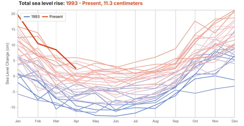
Figure 1: Sea Level Annual Cycle Over Time 1993-present (Malaysia) (Earth., 2025)
Within this context, this article explores Malaysia’s sea-level rise challenge through the lens of the IPCC AR5 framework, a tool that helps unpack the drivers of risk and inform adaptation strategies.
The IPCC AR5 risk framework: a local lens on Malaysia’s SLR
The Fifth Assessment Report (AR5) by the Intergovernmental Panel on Climate Change (IPCC) introduced a structured approach to understanding climate-related risks. It categorizes these risks into three interconnected components:
Risk=f(Hazard, Exposure, Vulnerability)
- Hazard: The climate-driven threat itself. In this case, sea-level rise and more frequent coastal flooding.
- Exposure: The presence of people, infrastructure, ecosystems, or assets in in flood risk zones that could be adversely affected by hazards
- Vulnerability: How sensitive the above are, and how well they can cope and adapt to the risk. This sensitivity is shaped by social, economic, and environmental conditions.
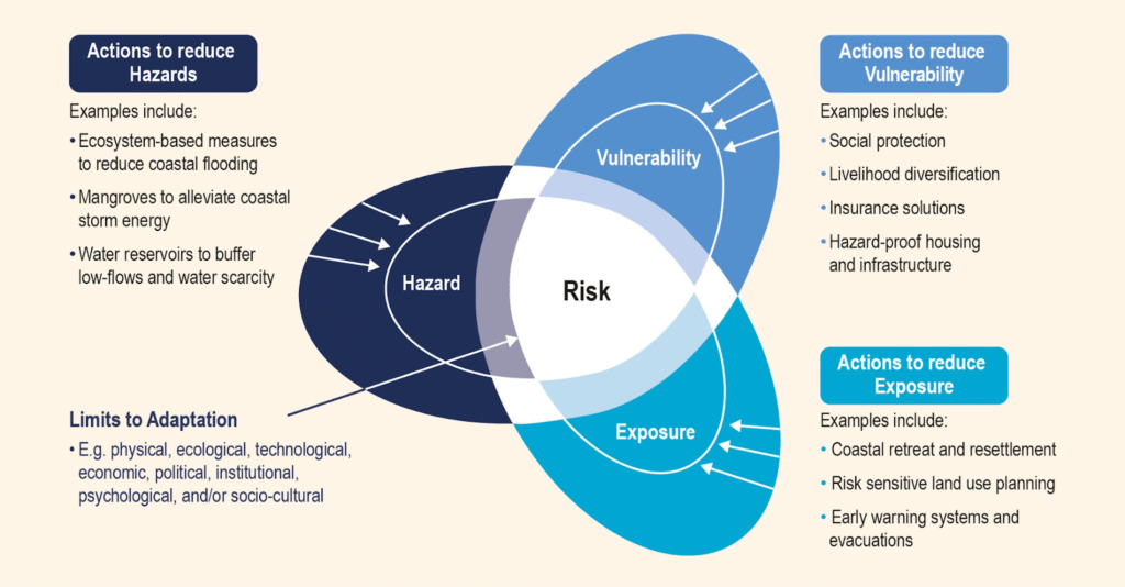
Figure 2: The IPCC AR5 framework shows that risk is driven by the interaction of hazard, exposure and vulnerability. As such, reducing risk (through climate adaptation strategies) can be achieved by reducing vulnerability, reducing exposure, or mitigating hazards. (IPCC, 2014)
Hazard
Sea-level rise is not a slow, silent process—it progressively alters coastlines by elevating the water baseline. Even minor increases in sea level can greatly enhance the depth and extent of coastal floods. In Malaysia, local factors such as land subsidence, particularly in areas with excessive groundwater extraction and natural soil compaction, lead to a relative sea-level rise that can exceed global averages, especially in urban or agricultural areas (Ghazali et al.,2017).
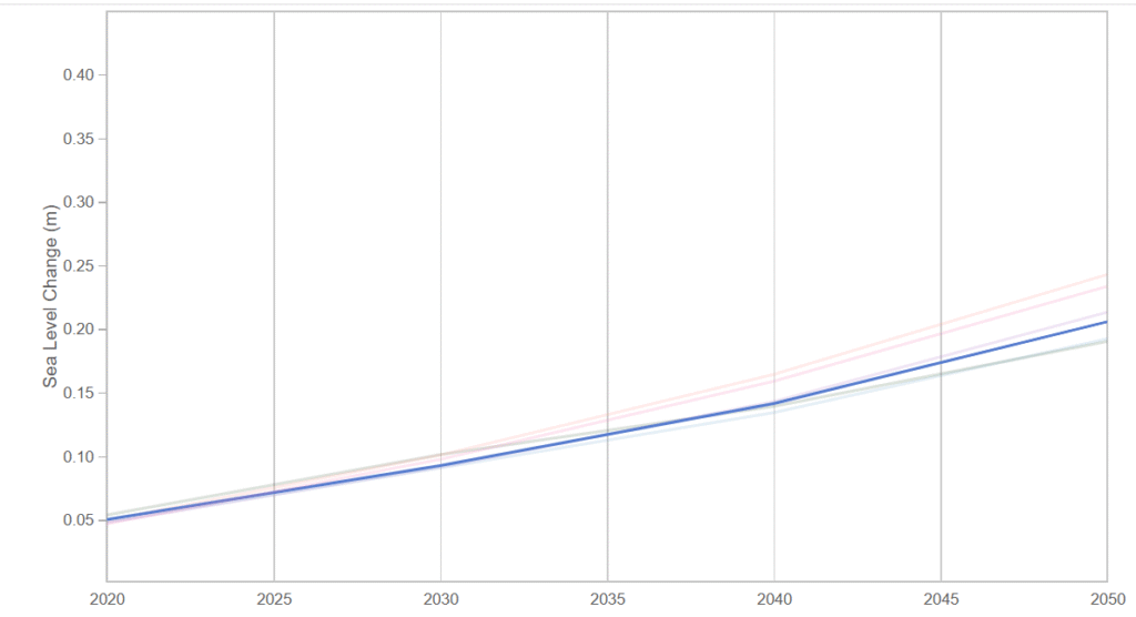
Figure 3: Projected Sea Level Rise for Malaysia from 2020-2050 (Earth., 2025)
Beyond overt flooding, saltwater intrusion poses a more subtle but equally alarming threat. Saltwater intrusion driven by sea-level rise (SLR) contaminates freshwater supplies, threatens paddy irrigation, and damages soil fertility, placing additional stress on agriculture (Suhaila et al., 2023; Birati et al., 2025; New Straits Time., 2025). These changes also disrupt coastal fisheries, threatening livelihood dependent on marine biodiversity (Consumer’s Association of Penang (CAP)., 2023; AlJazeera., 2024) .
Exposure
Malaysia’s extensive coastline hosts around 70% of its population, drawn by economic opportunities and transport links (Sofia, E. et al., 2019). Major urban and industrial centres such as Penang and Klang Valley (including Kuala Lumpur and Port Klang) harbour much of Malaysia’s population and industrial output, thus being vital engines of national GDP (The Malaysian Reserve., 2024; Kenanga., 2025). This clustering of critical infrastructure and dense settlements close to sea level amplifies the potential impacts of sea-level rise.
The northwest coastal plain, covering parts of Kedah and Perlis, is flat, low-lying and vital for paddy cultivation and rice production. Large areas of farmland lie within flood-prone and salinity-exposed zones. In September 2024, over 5,388 hectares of paddy fields under the Muda Agricultural Development Authority (MADA) were affected by flooding in Kedah and Perlis (BERNAMA., 2024). By November the same year, 3,233 hectares of padi fields in MADA’s Perlis zone were exposed to inundation (NADMA., 2025). Additionally, research in Kuala Kedah documented yield loss in 30 hectares of paddy land due to saltwater intrusion from tidal encroachment (Sah et al., 2021).
A farmer in Kuala Sungai Yan shows a homemade irrigation system to prevent saltwater from entering paddy fields. (New Straits Times., 2025)
Additionally, coastal habitats such as mangrove, estuaries and mudflats lie within flood-prone zones, making them highly vulnerable to rising seas and erosion. Malaysia has lost 15-20% of its mangrove forests along the coastline due to rising seas and coastal degradation. In Selangor, an estimated 1,878.5 hectares of coastal areas have been affected by erosion, further threatening these ecosystems and reducing their natural flood-buffering capacity (Sofia, E. et al., 2019)
Vulnerability
Hazards and exposure alone do not determine the scale of impact: the impact of SLR is not solely determined by how high the water rises. Vulnerability plays a crucial role. It reflects susceptible people, ecosystems, and economies systems to disruption.
In Malaysia, vulnerability is influenced by several factors. For example, facilities in urban coastal areas such as ports, roads, and power plants are highly sensitive to disruption. For instance, flooding in 2021 severely disrupted operation at Port Klang, Malaysia’s key logistics hub, leading to delays in cargo movements and interruptions across national supply chains (The Maritime Executive., 2021). Flooding not only causes direct physical damages and costly repairs, but also triggers wider ripple effects across sectors like trade, tourism, and supply chains.
Agricultural communities are vulnerable due to their reliance on freshwater stability. Even minimal saltwater intrusion can sharply reduce paddy yields, while limited income diversity and adaptive capacity heighten vulnerability for paddy farmers (Sah et al., 2021).
Mangrove forests play a crucial role in reducing wave energy and stabilizing shorelines. They are also rich nursing grounds for marine biodiversity. These ecosystems also provide critical services to human livability, for example, from fisheries that provide economic livelihood. However, urban expansion and aquaculture development have significantly degraded these ecosystems, diminishing their protective functions and leaving the coastline more exposed to erosion and flooding (Alongi et al., 2015).
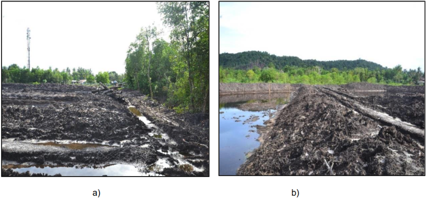
Figure 4: The mangrove clearing area at Cherating for aquaculture pond extension (Ahmad, Z. et al., 2018)
Adapting to SLR—Strategies
Collectively, these three dimensions above highlight how Malaysia’s SLR risks would benefit from a multifaceted adaptation response. The AR5 framework helps break down these threats and guide interventions. Since direct strategies to reduce the hazard itself (i.e., lowering sea levels) are not feasible, adaptation strategies instead focus on reducing exposure and vulnerability.
Hard engineering
Seawalls and breakwaters have been the go-to for coastal protection. Seawalls are constructed along the shoreline, made of concrete, masonry, or sheet piles. Seawalls help protect against wave action and reduce coastal erosion. On the other hand, breakwaters, made of concrete, rock, or oyster shells, are built further away from land to dissipate wave energy headed beachward.
These structures are relatively easy to construct, though the specific type of structure and engineering design is highly dependent on the characteristics of the coastline and the tidal behavior. Once built, the structures can also double as public spaces; for example, tourists and locals are fond of walking along the Esplanade seawall in Penang to take in the view. However, hard structures tend to be costly and may negatively affect nearby natural habitats and the overall beach ecology.
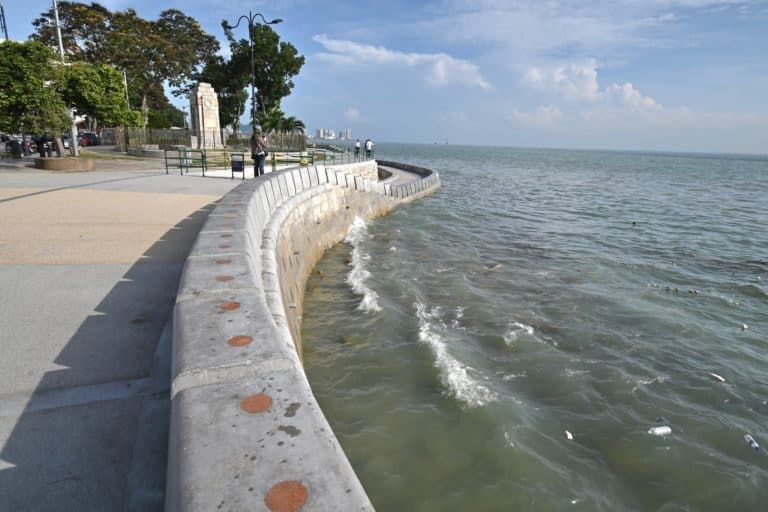
Esplanade seawall, Penang (Source)
Marang breakwater, Terengganu (Source)
Unlike a seawall, a revetment is more inclined. In Kuala Kedah, for example, a 2.5 km revetment was installed along the northern segment of the study area, an 80 km coastline spanning from Kuala Perlis, Perlis to Yan, Kedah (Sah et. al, 2021). It was predicted that the revetment could decrease the area affected by inundation by 50% for the entire study area, even though the forecast only included coastal protection in the northern segment. The study also found that seawater advancement in the northern segment could be reduced by more than 50% with coastal protection with a 10% reduction in the southern segment without coastal protection.

Rock revetment in Kedah (Source)
Given that SLR caused 75% of paddy losses since 2016, the study also demonstrates how the installation of a hard structure in a segment of the coastline could potentially improve the socioeconomic state of the community. Not only can paddy cultivation continue due to decreased SLR effects, but the area will also have more development opportunities.
Nature-based solutions
Nature-based solutions (NbS) have emerged as a key component of climate adaptation strategies, offering ample benefits while minimizing the risk of unintended harm. In Malaysia, mangrove restoration and planting efforts are increasing in prevalence. The extensive root systems of mangroves allow for sediment retention and the reduction of wave action. Effective mangrove planting can thus provide long-term protection against SLR, whilst supporting the local ecology by acting as a natural habitat.
Restoration and planting efforts must consider the growth dynamics of mangroves. As discussed earlier, existing mangrove populations are themselves vulnerable to SLR, with landward treelines retreating inland and seaward margins eroding (Zulkifli et al., 2017). A successful example of local mangrove planting can be observed in Sungai Haji Dorani shown below.
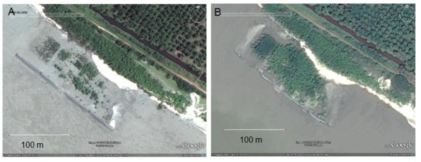
Sungai Haji Dorani, Malaysia. A) After mangrove planting, 2012. B) Mangroves well established, 2015. (Source)
Unfortunately, trees do not grow in a day and mangrove restoration requires a longer time for the benefits to be realised, which can be a challenge given the urgency of current adaptation needs. Considering the timespan for mangrove growth, other NbS can also be considered, in tandem.
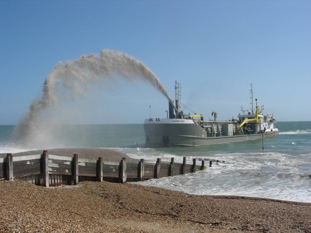
Beach nourishment is one example of a soft engineering approach. This involves replenishing eroded beaches with sand, which can help maintain a natural coastline and protect against erosion. Though effective in the short to medium term, this method is costly and requires frequent maintenance. Beach nourishment efforts have been known to gain pushback from the tourism industry, especially from hotels and resorts located near the coast (Mohd Ghazali, 2004).
The rainbow method used in Australia as a form of beach nourishment (Source)
Institutional and community approaches
There are also adaptation strategies that primarily address vulnerability, while also influencing exposure by shaping where and how people live along the coast.
Policy and planning play a critical role in adapting to SLR. For example, land-use planning and zoning regulations can be enforced to restrict development in vulnerable areas, forming a part of a broader integrated coastal management strategy. However, such measures often require long time horizons before benefits are realized.
In contrast, early warning systems and evacuation plans offer immediate protection to ensure the safety of the coastal population more promptly. Bangladesh provides a strong example through its disaster risk reduction strategies, combining cyclone shelters with early warning systems (Kazi & Urrutia, 2022).
At the community level, community-based adaptation allows solutions to be tailored to local needs and knowledge. In Kuala Kedah, for example, fishermen and farming communities use early warning systems to manage coastal flooding risks which is separate from the warning provided by the National Flood Forecasting And Warning Centre. Awareness programs and education are also crucial in building a community that is aware of its exposure and vulnerability towards SLR. Beyond Malaysia, the Maldives has adopted community-based adaptation programs focused on raising awareness about climate change, promoting sustainable tourism, and diversifying livelihoods (Gentile et al., 2023).
A combination of all three?
The Netherlands, as a low-lying delta highly vulnerable to inundation, has developed some of the world’s most advanced adaptation strategies to address sea-level rise (SLR). Three flagship programs illustrate different approaches:
- The Maeslantkering (Maeslant Barrier): A storm surge barrier designed to protect Rotterdam and the surrounding areas from extreme coastal flooding. It represents a large-scale engineered solution, demonstrating how hard infrastructure can provide immediate protection against hazards.
- The Zandmotor (Sand Motor): An innovative beach nourishment project where a large volume of sand is deposited along the coast. Over time, natural coastal processes distribute the sand, strengthening shorelines and providing a more sustainable alternative to repeated nourishment.
- Room for the River: A program that manages high water levels in rivers by allowing rivers to expand into designated floodplains. By creating space for water instead of constraining it, the program reduces urban flood risks while also enhancing ecological and recreational values.
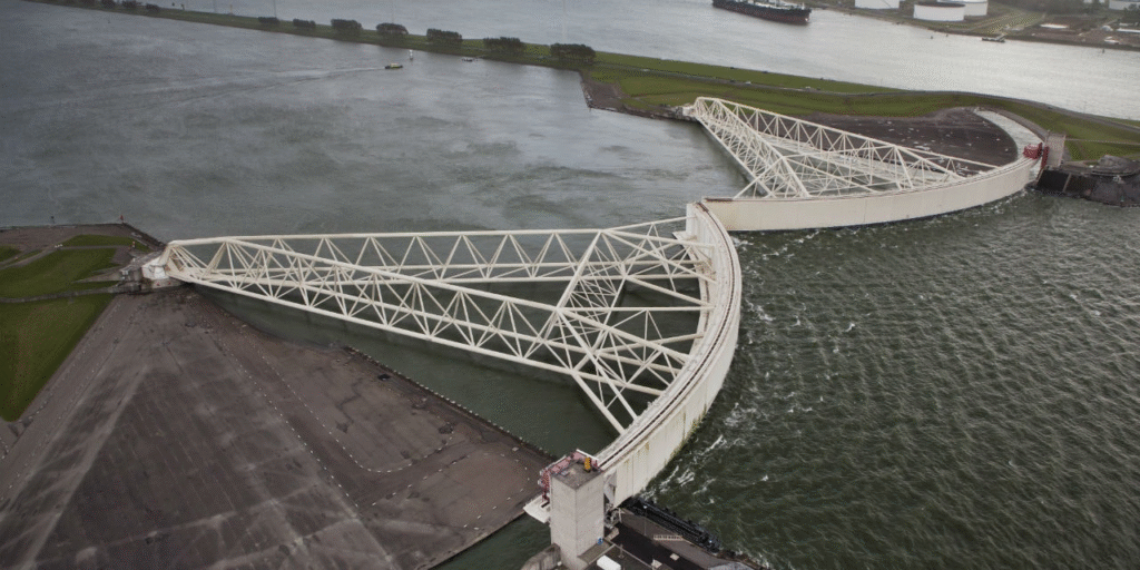
Maeslant Barrier, Netherlands (Source)
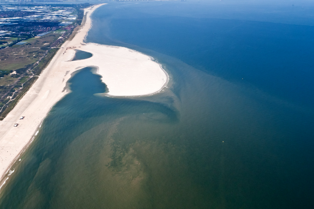
Zandmotor, Netherlands (Source)
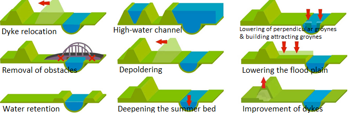
River management methods through Room for the River program (Source)
Concluding thoughts
While a wide range of strategies exists to adapt to SLR, significant challenges remain in their implementation. Financial constraints stand out the most, with hard structures racking up a high price. Equally, a lack of public awareness and political will may also hinder the progress of SLR adaptation in Malaysia, which emphasizes the need for education and advocacy. Effective coordination across stakeholders is also essential, particularly to ensure that the voices of coastal communities, as those most directly affected, are included in decision-making. Crucially, adaptation measures must be designed so that the solutions we apply do not further harm the communities we are trying to protect.
Ultimately, Malaysia’s exposure and vulnerability to SLR demand an urgent need for sustained adaptation solutions. Increased coastal flooding and saltwater intrusion, coupled with the susceptibility of coastal regions and the exposed agricultural areas and coastal cities, highlight the need to act across multiple fronts. Whether through hard or soft engineering, policy and planning reform, or community-based adaptation, solutions must be integrated into broader coastal management frameworks so that we are able to safeguard our coasts and communities against the long-term impacts of SLR.
Water is a fundamental element for life on Earth, covering nearly 71% of the planet’s surface and sustaining all living organisms. From the Milo ais we drink to the rice we grow, from powering industries to keeping ecosystems in balance, water shapes the way we live every day.
At the same time, water connects us deeply to the natural world, reminding us just how important it is to protect and manage it wisely. (Who hasn’t sat under a waterfall, enjoying the torrent of pitter-patter splashes on your back?)
In Malaysia, water is also at the frontline of climate adaptation. Too little or too much of it can disrupt lives, livelihoods, and in its most unpredictable, wipe away entire communities. In this 4-part series, we dive into the story of water in Malaysia and it relates to the climate and environment.
If you’re interested in…
- Understanding the issue of too little water (water scarcity), click here.
- What happens when there is too much water (sea level rise), click here.
- What happens in response to flooding (early warning systems), click here.
And to tie it all together, we take a look at the state of adaptation finance (here) in Malaysia.